Project showcase
George Street First New Town, Edinburgh – City of Edinburgh with Faithful & Gould, Atkins, Sustrans and Transport Scotland
George Street First New Town is part of Edinburgh’s plan for greater pedestrianised spaces and a greener, more accessible urban experience of the world heritage site. Careful attention to materials has been possible through partnerships with Edinburgh World Heritage, Historic Environment Scotland and the Cockburn Association.
Who is on the project team?
City of Edinburgh Council, Sustrans, Transport Scotland, Streets-UK, Faithful Gould Atkins, LDA Design, LUMA
Describe the context of this project?
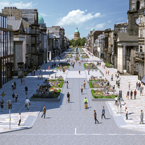
George Street First New Town (GSFNT) is a public realm improvement project within Edinburgh’s UNESCO World Heritage site and contains several of the critical nodes of Edinburgh’s wider active travel network.
The Georgian street provides for a wide range of functions, including high-end retail, offices, restaurants, bars/nightclubs, hotels and places of worship as well as some residential. This presents significant demands in terms of servicing.
In its current state, George Street is not effective either as a public space or as a movement corridor aligning to the Transport Hierarchy. Car parking dominates the street, uneven pavements pose accessibility challenges and places to rest are minimal.
The designs have been informed by a Getting Home Safely audit which will be critical to the overall impact of GSFNT , as the atmosphere of the street changes significantly at night. As part of the audit, a day and evening walkabout with key stakeholders, including Police Scotland, and elected members was followed by a workshop. Setting a precedent for wider city policies on social safety, this allowed stakeholders to consider the space from a different perspective and expand their understanding of how safe it feels for different groups.
George Street was identified within the Edinburgh Slavery and Colonialism Legacy Review Report. some figures prominently commemorated directly profited from the Caribbean slave trade, while milestone events in the abolition movement took place in buildings lining the street. The Edinburgh Caribbean Association have worked with the project team to include an Art Strategy telling this story.
How are you seeking to foster community?
GSFNT is a premier project in delivering The City Centre Transformation’s ambitions, in revolutionising transportation in and around the capital setting a standard of best practice in design and engagement and aligning with the transport hierarchy.
Proposals include wider pavements which will increase circulation space and accessibility for pedestrians. This is primarily achieved by reducing the road space and the significant removal car parking (spaces for blue badge holders will be provided). additionally, pedestrian crossings will be more convenient, direct and safer. A designated space for commercial seating will ensure the pavement width remains consistent and uninterrupted.
The realignment of bus routes, and non-essential traffic will facilitate a ‘European style’ cycling street within the central carriageway. This will provide a high-quality interface with both the City Centre to West Edinburgh Link and Meadows to George Street routes. This will create a network of strategic cycling routes through the city centre. The junctions of George Street will provide cycling and pedestrian priority.
Proposed palette of materials have been developed in close partnership with Edinburgh World Heritage, Historic Environment Scotland and the Cockburn Association. This will secure the longevity of the street as a public realm and heritage asset.
What is your sustainability strategy and how are you mitigating carbon use and construction pollution?
During Stage 3, an Economic Impact Assessment was undertaken to determine the potential economic impact of the project to the local economy. The report concluded that, over a 20-year period, the estimated cost-benefit analysis indicates a potential positive benefit-cost ratio of 2.2. This means generating a potential net Gross Value Added benefit to the economy of £95m. Other positive impacts include local job creation, environmental sustainability, increased property values, increased visitor spend and a healthier, safer and more relaxed urban environment alongside the focus on social safety already outlined.
Landscaped seating areas will be installed along George Street to provide attractive resting areas for those moving through the street. Sustainable Urban Drainage Systems (SUDS) have been incorporated within the design proposals. This introduction, which will be formed in both the soft landscaped areas and the main carriageway and will allow surface water to drain naturally via the creation of rain gardens, having zero impact on the capacity of existing drains and sewers. The planting will also slow the rate of surface water as plants filter, reuse and reduce flood risks. The incorporation of SUDS has been developed in line with the Council’s wider Green Blue network strategy. For more detailed technical specifications, please refer to the uploaded technical note.
Describe the social impact of the project: How is this place contributing to the economic, environmental and social wellbeing of its citizens?
As a part of the wider City Centre Transformation, George Street is anticipated to reduce transportation emissions by creating an attractive, safe, and accessible route for active travel. The design proposals balance the street’s critical functions both as a place and as an active travel corridor.
Realigning the wider transport network is a core objective of the project. Currently, there are no restrictions on general vehicle access on George Street. the Operational Plan proposes general traffic access be removed and a ‘pedestrian and cycle zone’ created managing access for essential vehicle movements (e.g. blue badge holders and daily servicing and deliveries). This maximises accessibility for people walking, wheeling and cycling. This also allows for the prioritisation of bus services on interconnecting streets, which will improve journey times. While the area is currently within a 20mph zone, physical and visual traffic calming within the design aims to further reduce vehicle speeds to that of the average cyclist (15mph). This transforms the function of the street, embodying the principles of transport hierarchy whilst achieving a high place function.
Thank you to Vestre and Tectonix for generously supporting The Pineapples 2026
 |  |
Thank you to ROCKWOOL Limited, Vestre and Tectonix for generously supporting The Pineapples 2026


Festival of Pineapples
24-26 February 2026
Pineapples prize giving night
April
Pineapples at Festival of Place
10 June 2026
© The Pineapples - Tweak Ltd. 124 City Road, London, EC1V 2NX. Tel: 020 3326 7238